

It is still dark outside when the alarm wakes us from our dreams and urges us out of our warm cocoons. Something exciting is going to happen today! It is our 8th wedding anniversary, and we have something special planned to celebrate, hiking to the highest peak of Australia, Mount Kosciuszko. After one last check of our backpacks, we jump into the car and make our way through beautiful and misty mountain roads up to Charlotte Pass, which is also the end of the road. We are very surprised to see many parked cars and people making their way to the trail; apparently, we are not that early after all…
Before hitting the trail, we have a quick bathroom break; that is the beauty of Australia as there are well-maintained public toilets in most of the National Parks and at the start of hikes. We are loading up our backpacks, and off we go; due to the height profile of the trail, we are hiking it anti-clockwise. After a few meters of walking, the trail starts to go down very steeply, which confuses us a bit as we were supposed to go up, right? Well, soon, we discover that the first few hundred meters or so are indeed steeply down to the first river crossing of the day. The crossing is the point where the Snowy River and Club Lake Creek meet, and it is beautiful and fun.

Down before up, and the first river crossing
Unfortunately, from the steep descent, we could already see what was in store for us after the river crossing, the same kind of steep path but then leading up again, a perfect start of the day with a major warm-up! Halfway through this first steep hill we take a break for breakfast with beautiful views over the main ranges.
As it is still very early in the morning, we expected to see some Australian wildlife, such as kangaroos jumping around, but to our surprise, there are none up here, potentially due to the height and lack of trees. The only company we have is from crows that seem to follow us for kilometer after kilometer.
Wet feet, and the view over Blue Lake
After this first steep section, we are relieved that the path continues with a more gradual climb, and we make our way to the following river crossing. As it has been a very wet year, this one is not very straightforward, or at least not for us…, and one of us ends up with very wet feet!
Another steep climb rewards us with mesmerizing views over Blue Lake. From here, you can take a side-track to the lake for a refreshing swim, or if you do an overnighter, you can pitch your tent here. As we have not walked this distance in a long time and are unsure how our bodies will respond, we decide to enjoy the view over the lake from where we are and continue with the main trail.

The best decision of the day: hiking poles
From here the trail goes up with a more gradual climb, and we have the genius idea to take out our hiking poles, and honestly, that was the best decision ever! For the next few kilometers, we feel like we are flying up the trail 😊. Full of energy, we are going up and up till we reach the top of Carruthers Peak, the views from the peak are just breathtaking, and this is a fantastic spot for a short break and to enjoy the quiet and tranquil surroundings.
From the top, the path leads down again with views over Club Lake and Albina Lake and eventually continues as a boardwalk to protect the fragile flora and fauna and to lead you along Mount Lee. The path becomes relatively narrow at the end of the boardwalk, with some scrambling, while circling around Mount Northcote.


The last climb, and everyone else
Turning the corner (so to speak), we were rewarded with fantastic views over the valley, and we could glimpse our end goal, Mount Kosciuszko! We were pleasantly surprised that the trail becomes a bit flatter for a while before heading into a stretch of stairs, slowly making our way closer and closer to the top.
Arriving at the end of the stairs took us a bit by surprise as this is the intersection between the Main Range Walk and the walk for those who opted to take the cable car from Thredbo. So, after being almost alone on the trail the whole morning, having to weave our way into the masses (even whole school classes) going up to the top of the mountain was a bit of an adjustment.
The top of Australia
While we were winding our way up the last kilometer of the hike, the anticipation grew and grew, and what a reward it was when we finally arrived at the peak! Beautiful and mesmerizing views in all directions, this climb was worth it, and what a way to celebrate our Anniversary on the top of Australia!


We found a beautiful spot and had our lunch while enjoying the views and our accomplishments. Of course, this was not the end of the walk as from here, we still had to make our way down and back to the car. So after our much-needed and deserved break, we packed up our bags, and off we went.
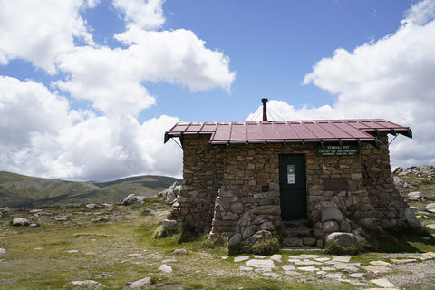
Seamans Hut, and the walk back down
Luckily, there was a public toilet on the route (the highest public toilet in Australia, you just got to love it!), and after a much-needed bathroom break we continued our way back to Charlotte Pass. About 1.5 kilometers from Rawson Pass, we came across Seamans hut. The hut has a sad story as it was constructed due to a young man getting lost in a snow blizzard, losing his life. His family donated money for this hut to be built as an emergency shelter for those who need it to ensure this tragedy would not repeat itself.
After Seamans Hut the route continues to follow the Fire Trail and gradually winds its way down for about another 7 kilometers. While this part of the trail is maybe not as thrilling as the first half, we were constantly rewarded with beautiful valley views and river crossings.
After about 22 kilometers and 8 hours later (of which 6 hours were active walking), we arrived back at the car, tired but extremely satisfied with this amazing hike!


What we would tell you before you go
Some takeaways from this hike are to take your hiking poles with you and use them from the first step on the trail to the very last one 😊. Trust us; this will help immensely! We were fortunate that it was a bit of a cloudy day and the sun and clouds alternated perfectly. On sunny days, make sure to take a hat and a lot of sunscreen with you. Being quite high up, there is no shelter, and you are constantly exposed, so the risk of sunburn is real and high. Other than that, embark on this beautiful trail and enjoy it to the fullest!
Happy Trails,
Jay & Maud

